Garmin GPSMAP-296 | |
| |
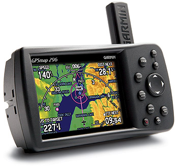
GPSMAP-296 | US$1,495.00
|
| |
| The GPSMAP 296 builds on the tradition of Garmin aviation handhelds like the GPSMAP 196 and GPSMAP 295. New features like terrain cautions and alerts, sectional chart-like topographic data, a built-in obstacle database of the U.S., and a transparent navigation arc view for course, speed, and distance information lead the list of advances. The GPSMAP 296 also features USB data transfer, faster processing speed, and a rechargeable lithium-ion battery pack. Press a button, and you have your choice of the unit's automotive or marine modes.
An automatic logbook also calculates your flight time and automatically records departure and arrival locations. When used with Garmin's free logbook softwareFlightBookthis feature makes light work of maintaining your logbook. Your flight information will be stored in the unit and can be downloaded to this exclusive Flightbook software at any time.
Garmin delivers terrain awareness in an intuitive Terrain mode on the GPSMAP 296. The unit combines GPS position, GPS altitude and topographical mapping to give pilots a vivid depiction of potential terrain hazards.
Pilots gain terrain awareness in a number of ways:
Terrain and obstacle information
By using visual cues and tone alerts, pilots can be aware of potentially dangerous terrain or obstacle conflicts along the current flight path. The unit also offers a configurable look-ahead warning function which gives the pilot additional time to make critical decisions.
Configurable buffer zones
The pilot can set the minimum limits to receive terrain cautions. The unit then presents potential hazards in yellow (to indicate ground proximity of 500-1000 feet) and red (to indicate ground proximity of 100 feet or less).
Obstacles database
Users can view the elevation or relative altitude of any obstacle (towers, buildings, etc.) within the units built-in database. (This feature is only available with the Americas version.)
Pop-up alerts
Terrain proximity cautions and alerts pop up as digital thumbnail images in the lower left-hand corner of any page whenever a potential hazard conflict looms ahead.
The GPSMAP 296 is designed to move seamlessly between an aircraft, vehicle, or boat:
Automotive Mode
Provides automatic route generation, turn-by-turn guidance, and voice prompts, plus a built-in worldwide database of borders and major cities. The optional Auto Kit includes two mounts, a cigarette-lighter adapter with speaker output, a 128-MB data card, and a MapSource® City Select® CD-ROM for detailed mapping and address lookup capabilities.
Marine Mode
Features a worldwide marine database and U.S. tide data. When coupled with the optional Marine Kit (64-MB data card and MapSource BlueChart® CD-ROM), the unit displays such information as depth contours, inter-tidal zones, spot soundings, wrecks, navaids, port plans, restricted areas, cable areas, anchorages, and much more.
Garmin part number: 010-00356-00
GPSMAP 296 Suggested Retail Price:
$1595.00 U.S.D. (for domestic US market only)
GPSMAP 296 features
WAAS-capable GPS receiver for enhanced lateral/vertical guidance
Crisp, high-resolution display (480 x 320 pixel count), 256-color TFT display (3.8 inches diagonally)
3.8"-diagonal display; 480 x 320 pixels
5.7" W x 3.2" H x 1.9" D unit dimensions
200-MHz processor for fast redraw and routing
Up to 15 hours battery life (typical use backlight conditions); 8 hours full backlight brightness
Rechargeable lithium-ion battery pack
GA 25BNC remote antenna
Automotive and marine modes for easy navigation in a vehicle or boat
Detailed basemap includes highways, major roads, borders, rivers, lakes, and tide stations
Accepts data from Garmins MapSource products (City Select for driving, BlueChart for saltwater, and Recreational Lakes with Fishing Hot Spots® for freshwater)
15/11 (text/voice) languages
Waterproof to IEC 60529 IPX7 standards (submersible in 1 meter of water for up to 30 minutes)
Weighs just 12 ounces
50 reversible routes (300 waypoints each), 15 saved tracks (700 trackpoints each), TracBack® technology, 3000 waypoints with graphical icon identification
Adjustable quad-helix receiving antenna with remote antenna capability
Voice prompt guidance when the 12-volt / speaker cable is connected
Separate serial and USB interfaces; 2 RS-232 serial ports
|
| |
| Payment Methods |
| Visa, MasterCard, Interac, Certified Cheque, Money Order, Wire |
|